An update on the Great Smoky Mountains website is reporting that the Little River/Jakes Creek Trail access road in the Elkmont area will be closed to public use until October 23rd now.
The repaved road, with new parking areas near the Little River and Jakes Creek trailheads, was scheduled to reopen on October 15th.
For now, parking for trail users is available on an extremely limited basis at the walk-in camping area in B loop. There's a marked route through the campground to both trailheads.
Click for more information on hiking the popular Little River Trail and the Cucumber Gap Trail (from the Jakes Creek Trailhead).
Jeff
HikingintheSmokys.com
Showing posts with label trail. Show all posts
Showing posts with label trail. Show all posts
Tuesday, October 12, 2010

Saturday, October 2, 2010
In a Quandary
The main hiking objective of our recent trip out west was to summit Quandary Peak in central Colorado. At 14,265 feet, Quandary is the 13th highest peak in Colorado, and the highest mountain in the Tenmile Range.
According to 14ers.com the peak’s name comes from a group of miners who were unable to identify a mineral sample found on its slopes in the 1860s. The group was in a quandary over the exact nature of the mineral, and ended up naming the mountain from which it came, “Quandary Peak.”
Arriving at the trailhead near Hoosier Pass that morning, the temperature gauge read a chilly 36 degrees. After a long and very hot summer, this was a bit of a shock to the system.
Although it’s a relatively short hike, and has less elevation gain when compared to other Fourteeners, the trail still packs a punch. Much of the climbing occurs in two relatively short sections. One climbs 1300 feet over a 0.9-mile section roughly midway through the hike. The second climbs 1100 feet during the final 0.8-mile push to the top:
 By the time we arrived at the summit the sun was already high in the sky, making the thin air feel relatively warm.


 Although the views from the summit were quite spectacular, the highlight of the hike was coming face to face with a family of mountain goats. We first saw them from a distance hanging around the pathway several hundred yards up the trail. However, as we got closer, although curious, they didn’t move. In fact, the largest Billie (male goat) decided to lay down on the trail just as we got close enough to look into his eyes.
You could say that we were now “in a quandary” as to what to do next. We were just about to go off trail and walk around the road block, but noticed a group of hikers approaching from behind us. The sight of their dog provided the motivation for the goats to finally move out. Because we were on a fairly narrow ridgeline we basically followed the goats for about a quarter-of-a-mile until a group of hikers descending from above effectively forced them off the trail, and out of our way. Moving towards the edge of the ridge allowed me to get some great shots:


 After our hike, on the way back to Buena Vista, we stopped in the town of Fairplay for an ice cream at an old-fashioned soda fountain joint. The town is an absolute hidden gem. Although it plays up its association with the popular South Park animated sitcom, it’s really a small, laid-back rustic town with an old west vibe. There were no signs of over-commercialization, nor do I recall seeing any national chains of any type. We really wished we could’ve spent some more time there, but Kathy was nursing a massive headache from the altitude and just wanted to take a nap.
Speaking of South Park, the drive though this region is extremely beautiful. There are two main roads that pass through this high elevation grassland basin that encompasses roughly 1,000 square miles; one takes you from Buena Vista to Denver (U.S. 285), while the other travels from Buena Vista to Colorado Springs (U.S. 24). In 2009 South Park was designated as a National Heritage Area.
Trail: Quandary Peak Trail
Round-trip Distance: 6.75 miles
Elevation Gain: 3,450 feet
Trailhead Elevation: 10,850 feet
Summit Elevation: 14,265 feet
The trailhead is located roughly 8 miles south of Breckenridge/14 miles north of Fairplay, on the north side of Hoosier Pass in the White River National Forest.

Jeff
HikingintheSmokys.com Detailed trail information for the Great Smoky Mountains; trail descriptions, key features, pictures, maps, elevation profiles, news, books and more.
According to 14ers.com the peak’s name comes from a group of miners who were unable to identify a mineral sample found on its slopes in the 1860s. The group was in a quandary over the exact nature of the mineral, and ended up naming the mountain from which it came, “Quandary Peak.”
Arriving at the trailhead near Hoosier Pass that morning, the temperature gauge read a chilly 36 degrees. After a long and very hot summer, this was a bit of a shock to the system.
Although it’s a relatively short hike, and has less elevation gain when compared to other Fourteeners, the trail still packs a punch. Much of the climbing occurs in two relatively short sections. One climbs 1300 feet over a 0.9-mile section roughly midway through the hike. The second climbs 1100 feet during the final 0.8-mile push to the top:
 By the time we arrived at the summit the sun was already high in the sky, making the thin air feel relatively warm.


 Although the views from the summit were quite spectacular, the highlight of the hike was coming face to face with a family of mountain goats. We first saw them from a distance hanging around the pathway several hundred yards up the trail. However, as we got closer, although curious, they didn’t move. In fact, the largest Billie (male goat) decided to lay down on the trail just as we got close enough to look into his eyes.
You could say that we were now “in a quandary” as to what to do next. We were just about to go off trail and walk around the road block, but noticed a group of hikers approaching from behind us. The sight of their dog provided the motivation for the goats to finally move out. Because we were on a fairly narrow ridgeline we basically followed the goats for about a quarter-of-a-mile until a group of hikers descending from above effectively forced them off the trail, and out of our way. Moving towards the edge of the ridge allowed me to get some great shots:


 After our hike, on the way back to Buena Vista, we stopped in the town of Fairplay for an ice cream at an old-fashioned soda fountain joint. The town is an absolute hidden gem. Although it plays up its association with the popular South Park animated sitcom, it’s really a small, laid-back rustic town with an old west vibe. There were no signs of over-commercialization, nor do I recall seeing any national chains of any type. We really wished we could’ve spent some more time there, but Kathy was nursing a massive headache from the altitude and just wanted to take a nap.
Speaking of South Park, the drive though this region is extremely beautiful. There are two main roads that pass through this high elevation grassland basin that encompasses roughly 1,000 square miles; one takes you from Buena Vista to Denver (U.S. 285), while the other travels from Buena Vista to Colorado Springs (U.S. 24). In 2009 South Park was designated as a National Heritage Area.
Trail: Quandary Peak Trail
Round-trip Distance: 6.75 miles
Elevation Gain: 3,450 feet
Trailhead Elevation: 10,850 feet
Summit Elevation: 14,265 feet
The trailhead is located roughly 8 miles south of Breckenridge/14 miles north of Fairplay, on the north side of Hoosier Pass in the White River National Forest.
Jeff
HikingintheSmokys.com Detailed trail information for the Great Smoky Mountains; trail descriptions, key features, pictures, maps, elevation profiles, news, books and more.
Sunday, September 26, 2010
The Cerro Grande Route
Roughly 45 miles northwest of Santa Fe are the ancient ruins and deep canyons of Bandelier National Monument. Designated as a national monument in 1916, Bandelier preserves the homes of the Ancestral Pueblo people.
Archeological surveys show that the Ancestral Pueblos began building permanent settlements in Bandelier by 1150, but had moved to new homes along the Rio Grande by 1550.
The main portion of the park, in Frijoles Canyon, contains a number of ancestral homes and dwellings, kivas (circular, half-buried ceremonial structures), rock paintings and petroglyphs.
The last time we visited Bandelier we spent most of our time in Frijoles Canyon. This time we decided to hike the Cerro Grande Route, a trail located in the fairly isolated northwestern corner of the park. This “Route” offers a much different experience as compared to the rest of Bandelier. Instead of canyons and deserts, the trail explores the subalpine and montane forests of the Jemez Mountains.
Destination for the “Route” is the top of Cerro Grande Peak, Spanish for “Big Mountain”, which at 10,199 feet in elevation is the highest point in the park. The path alternates through open meadows, aspen groves and pine forests. Even in mid-September we still saw a wide variety of wildflowers.
 Through the first sections of trail we noticed a fair amount of evidence of the Cerro Grande Fire that burned 48,000 acres in 2000. The fire started as a controlled burn by the Forest Service, but got out of control as a result of high winds and eventually destroyed 235 homes in the Los Alamos area. By no means, however, does the fading damage detract from the sublime beauty of this hike.
Be sure to look for elk, in addition to the mule deer and pikas we saw along the way.
Most of the climbing comes in the last three quarters-of-a-mile or so. The hike ends at a fairly open meadow at the summit of the peak – it would be called a bald if it were in the Southern Appalachians. From the top you can see the Valles Caldera, the Sangro de Cristo Mountains and the Sandia Mountains. Actually, the views are much better just a couple hundred feet below the summit.
 Cerro Grande Peak forms part of the rim of the Valles Caldera, a twelve-mile-wide crater that formed when the earth collapsed after a catastrophic volcanic eruption took place here roughly 1.2 million years ago – very similar to how Yellowstone was created.
 The prominent valley that dominates the view from the top is known as the Valle Grande. In the center of the caldera, and on the far end of the Valle Grande, is Redondo Peak, which, geologically speaking, is a volcanic resurgent dome. Although no longer active, it was formed roughly 70,000 years after the main caldera-forming eruptions occurred.
 Several movies have been shot in and around the Valles Caldera, including The Gambler, Buffalo Girls, Last Stand at Saber River, The Missing and most recently, Seraphim Falls, which starred Liam Neeson and Pierce Brosnan.
In a couple of days I’ll be posting a report from our Tsankawi Loop hike, which is located in a separated section of Bandelier that took us up close to several cave dwellings and petroglyphs.
Trail: Cerro Grande Route
RT Distance: 4 miles
Elevation Gain: 1300 feet
Max Elevation: 10,199 feet
TH Location: 11.6 miles past the entrance to the Visitors Center

Jeff
HikingintheSmokys.com Detailed trail information for the Great Smoky Mountains; trail descriptions, key features, pictures, maps, elevation profiles, news, books and more.
Archeological surveys show that the Ancestral Pueblos began building permanent settlements in Bandelier by 1150, but had moved to new homes along the Rio Grande by 1550.
The main portion of the park, in Frijoles Canyon, contains a number of ancestral homes and dwellings, kivas (circular, half-buried ceremonial structures), rock paintings and petroglyphs.
The last time we visited Bandelier we spent most of our time in Frijoles Canyon. This time we decided to hike the Cerro Grande Route, a trail located in the fairly isolated northwestern corner of the park. This “Route” offers a much different experience as compared to the rest of Bandelier. Instead of canyons and deserts, the trail explores the subalpine and montane forests of the Jemez Mountains.
Destination for the “Route” is the top of Cerro Grande Peak, Spanish for “Big Mountain”, which at 10,199 feet in elevation is the highest point in the park. The path alternates through open meadows, aspen groves and pine forests. Even in mid-September we still saw a wide variety of wildflowers.
 Through the first sections of trail we noticed a fair amount of evidence of the Cerro Grande Fire that burned 48,000 acres in 2000. The fire started as a controlled burn by the Forest Service, but got out of control as a result of high winds and eventually destroyed 235 homes in the Los Alamos area. By no means, however, does the fading damage detract from the sublime beauty of this hike.
Be sure to look for elk, in addition to the mule deer and pikas we saw along the way.
Most of the climbing comes in the last three quarters-of-a-mile or so. The hike ends at a fairly open meadow at the summit of the peak – it would be called a bald if it were in the Southern Appalachians. From the top you can see the Valles Caldera, the Sangro de Cristo Mountains and the Sandia Mountains. Actually, the views are much better just a couple hundred feet below the summit.
 Cerro Grande Peak forms part of the rim of the Valles Caldera, a twelve-mile-wide crater that formed when the earth collapsed after a catastrophic volcanic eruption took place here roughly 1.2 million years ago – very similar to how Yellowstone was created.
 The prominent valley that dominates the view from the top is known as the Valle Grande. In the center of the caldera, and on the far end of the Valle Grande, is Redondo Peak, which, geologically speaking, is a volcanic resurgent dome. Although no longer active, it was formed roughly 70,000 years after the main caldera-forming eruptions occurred.
 Several movies have been shot in and around the Valles Caldera, including The Gambler, Buffalo Girls, Last Stand at Saber River, The Missing and most recently, Seraphim Falls, which starred Liam Neeson and Pierce Brosnan.
In a couple of days I’ll be posting a report from our Tsankawi Loop hike, which is located in a separated section of Bandelier that took us up close to several cave dwellings and petroglyphs.
Trail: Cerro Grande Route
RT Distance: 4 miles
Elevation Gain: 1300 feet
Max Elevation: 10,199 feet
TH Location: 11.6 miles past the entrance to the Visitors Center
Jeff
HikingintheSmokys.com Detailed trail information for the Great Smoky Mountains; trail descriptions, key features, pictures, maps, elevation profiles, news, books and more.
Thursday, September 23, 2010
The Top of Texas
After staying in Van Horn the night before, we made the 60-mile drive north in the early morning darkness. My goal was to arrive just outside of Guadalupe Mountains National Park in order to a get a photo of El Capitan just as the sun begins to shine on the dramatic rock face of the mountain that stands at the southern terminus of the Guadalupe range.
 With an elevation of 8,749 feet, Guadalupe Peak is the highest point in Texas, and, is the 14th highest state high point. It’s also one of only four state highpoints that’s located within a national park - Denali, Mount Rainier and Clingmans Dome being the other three.
The hardest part of the hike is at the very beginning in which the trail ascends a series of switchbacks over the course of the first mile-and-a-half or so. Hikers can use the parking lot and the highway far below to gauge their progress.
During this first section the trail climbs the east face of the peak, which means hikers are fully exposed to the hot desert sun. I highly recommend starting this hike before sunrise in order to knock-out as much of this section as possible during the relative cool of the morning. It's also a good idea to start early so that you’ll have time to get off the mountain before summer afternoon thunderstorms arrive.
 At roughly 7000 feet in elevation, and 1.7 miles from the trailhead, the trail skirts a relatively narrow ledge. Although not exceedingly dangerous, you'll still want to take your time through this short section of trail. Just beyond this point the switchbacks mercifully come to an end (although they'll inflict more pain on the way down). Soon the trail winds around the other side of the mountain and reaches some much appreciated shade. From here the grade became much easier and remained relatively moderate for the rest of the hike.
 As we traveled upward we saw numerous Northern Harriers flying just above us. Up at the summit we also saw a few Golden Eagles and a couple of Peregrine Falcons soaring and gliding on the thermal updrafts.
At the second cliff section:
 The photo above includes a young man from New Zealand and his girlfriend getting ready to cross the highest bridge in Texas. Just days before a 7.1 magnitude earthquake hit near his hometown just outside of Christchurch. It took a day or two, but he finally received confirmation that his entire family was alright. He said his dad, who happens to be a building inspector, was keeping extremely busy in the aftermath of the quake. Coincidentally, the young Kiwi just happens to work as a rafting guide on the Pigeon River in Tennessee.
Just past the bridge we began the final climb to the top. Over the last quarter mile route finding became a little difficult. We made the same mistake a guy in front us made by missing the trail as it heads-off towards the right. Consequently, we took a route that required a little bit of scrambling. No big deal, it just would’ve been easier had we stayed on the main trail.
At the summit is a stainless steel memorial that was erected by American Airlines in 1958 to commemorate the 100th anniversary of the Butterfield Overland Mail Route, a 2800-mile stagecoach route that passed on the south side of the mountain. On one side of the pyramid is the American Airlines logo. Another side displays a U.S. Postal Service tribute to the Pony Express Riders of the Butterfield Stage. The third displays a compass with the logo of the Boy Scouts of America.
 From the summit we could see a line of thick high clouds extending from one end of the horizon to the other in the far off distance (they say you can see more than 100 miles away). These were likely the leading bands of Hurricane Hermine that was pummeling central and east Texas that day.
Although the hurricane had no impact on our hike, hikers should always expect high winds on the mountain – especially during the winter months when winds can exceed 80 MPH on a fairly regular basis.
Looking towards the north from the summit:
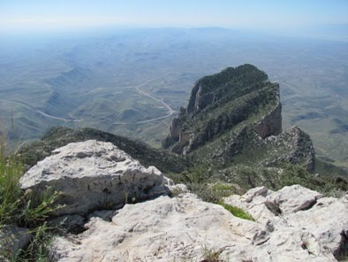
 Looking down on El Capitan and Highway 62/180 far below:
 The park also recommends that you take a full gallon of water. I only took about 100 ounces, thinking that would be enough given the relatively cool weather that day. I barely had enough, however. During peak summer months I would definitely take the parks’ recommendation of one full gallon.
One final note about this part of the country: After our hike we had planned to attend the Evening Star Party at the McDonald Observatory 65 miles south of Van Horn. Every Tuesday, Friday and Saturday the observatory invites the public to view the universe through 16 and 22-inch telescopes located atop Mount Locke and Mount Fowlkes (6300-6800 feet). The observatory in the remote Davis Mountains offers some of the darkest night skies in the continental United States. Unfortunately Hurricane Hermine wasn’t going to allow that to happen that night. As the early evening progressed the clouds continued to thicken, so we decided to cancel our plans. However, we did hear a lot of great things about the program and sounds like it would be a great excursion if you’re in the area.
Trail: Guadalupe Peak Trail
RT Distance: 8.5 miles
Elevation Gain: 2927 feet
Max Elevation: 8749 feet


Jeff
HikingintheSmokys.com Detailed trail information for the Great Smoky Mountains; trail descriptions, key features, pictures, maps, elevation profiles, news, books and more.
 With an elevation of 8,749 feet, Guadalupe Peak is the highest point in Texas, and, is the 14th highest state high point. It’s also one of only four state highpoints that’s located within a national park - Denali, Mount Rainier and Clingmans Dome being the other three.
The hardest part of the hike is at the very beginning in which the trail ascends a series of switchbacks over the course of the first mile-and-a-half or so. Hikers can use the parking lot and the highway far below to gauge their progress.
During this first section the trail climbs the east face of the peak, which means hikers are fully exposed to the hot desert sun. I highly recommend starting this hike before sunrise in order to knock-out as much of this section as possible during the relative cool of the morning. It's also a good idea to start early so that you’ll have time to get off the mountain before summer afternoon thunderstorms arrive.
 At roughly 7000 feet in elevation, and 1.7 miles from the trailhead, the trail skirts a relatively narrow ledge. Although not exceedingly dangerous, you'll still want to take your time through this short section of trail. Just beyond this point the switchbacks mercifully come to an end (although they'll inflict more pain on the way down). Soon the trail winds around the other side of the mountain and reaches some much appreciated shade. From here the grade became much easier and remained relatively moderate for the rest of the hike.
 As we traveled upward we saw numerous Northern Harriers flying just above us. Up at the summit we also saw a few Golden Eagles and a couple of Peregrine Falcons soaring and gliding on the thermal updrafts.
At the second cliff section:
 The photo above includes a young man from New Zealand and his girlfriend getting ready to cross the highest bridge in Texas. Just days before a 7.1 magnitude earthquake hit near his hometown just outside of Christchurch. It took a day or two, but he finally received confirmation that his entire family was alright. He said his dad, who happens to be a building inspector, was keeping extremely busy in the aftermath of the quake. Coincidentally, the young Kiwi just happens to work as a rafting guide on the Pigeon River in Tennessee.
Just past the bridge we began the final climb to the top. Over the last quarter mile route finding became a little difficult. We made the same mistake a guy in front us made by missing the trail as it heads-off towards the right. Consequently, we took a route that required a little bit of scrambling. No big deal, it just would’ve been easier had we stayed on the main trail.
At the summit is a stainless steel memorial that was erected by American Airlines in 1958 to commemorate the 100th anniversary of the Butterfield Overland Mail Route, a 2800-mile stagecoach route that passed on the south side of the mountain. On one side of the pyramid is the American Airlines logo. Another side displays a U.S. Postal Service tribute to the Pony Express Riders of the Butterfield Stage. The third displays a compass with the logo of the Boy Scouts of America.
 From the summit we could see a line of thick high clouds extending from one end of the horizon to the other in the far off distance (they say you can see more than 100 miles away). These were likely the leading bands of Hurricane Hermine that was pummeling central and east Texas that day.
Although the hurricane had no impact on our hike, hikers should always expect high winds on the mountain – especially during the winter months when winds can exceed 80 MPH on a fairly regular basis.
Looking towards the north from the summit:
 Looking down on El Capitan and Highway 62/180 far below:
 The park also recommends that you take a full gallon of water. I only took about 100 ounces, thinking that would be enough given the relatively cool weather that day. I barely had enough, however. During peak summer months I would definitely take the parks’ recommendation of one full gallon.
One final note about this part of the country: After our hike we had planned to attend the Evening Star Party at the McDonald Observatory 65 miles south of Van Horn. Every Tuesday, Friday and Saturday the observatory invites the public to view the universe through 16 and 22-inch telescopes located atop Mount Locke and Mount Fowlkes (6300-6800 feet). The observatory in the remote Davis Mountains offers some of the darkest night skies in the continental United States. Unfortunately Hurricane Hermine wasn’t going to allow that to happen that night. As the early evening progressed the clouds continued to thicken, so we decided to cancel our plans. However, we did hear a lot of great things about the program and sounds like it would be a great excursion if you’re in the area.
Trail: Guadalupe Peak Trail
RT Distance: 8.5 miles
Elevation Gain: 2927 feet
Max Elevation: 8749 feet
Jeff
HikingintheSmokys.com Detailed trail information for the Great Smoky Mountains; trail descriptions, key features, pictures, maps, elevation profiles, news, books and more.
Thursday, June 17, 2010
Photos from the trail
Below are several photos from the three trails we hiked during our recent visit to the Great Smoky Mountains.
The footbridge over the Rough Fork of the Cataloochee Creek is located near the Caldwell Fork Trailhead. According to Hiking Great Smoky Mountains by Rodney and Priscilla Albright, it's the longest footbridge in the Great Smoky Mountains:
 While hiking the Boogerman Loop we saw three snakes - I nearly stepped on two of them:
 Beautiful forest scene on the loop hike:
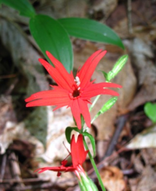
 One of many fire pinks we saw on the Boogerman Loop:
 As mentioned in a post last week, we encountered a lot of rain during our hike to Hen Wallow Falls. We were extremely fortunate to have a 15 minute break in the rain just as we arrived at the falls, allowing us to enjoy them and shoot a few pictures:
 Lots of green on the Lumber Ridge Trail out of Tremont:
 There were a few places along Lumber Ridge that provided views of the surrounding mountains through the trees:
 There were also quite a few small azaleas bushes that were in full bloom along the trail as well:

For more information and more details on each of these hikes, please click on the following links:
* Boogerman Loop Hike
* Hen Wallow Falls
* Lumber Ridge Trail
Jeff
HikingintheSmokys.com Detailed information on trails in the Smoky Mountains; includes trail descriptions, key features, pictures, video, maps, elevation profiles, news, and more.
The footbridge over the Rough Fork of the Cataloochee Creek is located near the Caldwell Fork Trailhead. According to Hiking Great Smoky Mountains by Rodney and Priscilla Albright, it's the longest footbridge in the Great Smoky Mountains:
 While hiking the Boogerman Loop we saw three snakes - I nearly stepped on two of them:
 Beautiful forest scene on the loop hike:
 One of many fire pinks we saw on the Boogerman Loop:
 As mentioned in a post last week, we encountered a lot of rain during our hike to Hen Wallow Falls. We were extremely fortunate to have a 15 minute break in the rain just as we arrived at the falls, allowing us to enjoy them and shoot a few pictures:
 Lots of green on the Lumber Ridge Trail out of Tremont:
 There were a few places along Lumber Ridge that provided views of the surrounding mountains through the trees:
 There were also quite a few small azaleas bushes that were in full bloom along the trail as well:

For more information and more details on each of these hikes, please click on the following links:
* Boogerman Loop Hike
* Hen Wallow Falls
* Lumber Ridge Trail
Jeff
HikingintheSmokys.com Detailed information on trails in the Smoky Mountains; includes trail descriptions, key features, pictures, video, maps, elevation profiles, news, and more.
Thursday, February 25, 2010
Contruction season in the Smokies to begin Monday
As part of the American Recovery and Reinvestment Act, and the Federal Lands Highway Program, several park improvement projects will be conducted in the Great Smoky Mountains this year.
Beginning this Monday, and lasting throughout the spring and summer, over $93,300,000 worth of improvements will be made to park roads and facilities.
The park has recently published a summary of the projects, which includes project details, as well as road and trail closures.
Beginning on Monday, March 1, the first major project to kick-off the season will be the repavement of the Cades Cove Loop Road. Here's the complete list of projects and expected closures:
• Cades Cove Loop Road will be closed to all public use from March 1 thru May 21 for repaving. This will impact the Forge Creek Road, Parson Branch Road and Rich Mountain Road, as well as the Abrams Falls Trail, Cooper Road Trail, Gregory Bald Trail, Gregory Ridge Trail, Hannah Mountain Trail, Indian Grave Gap Trail and Rabbit Creek Trail.
• Clingmans Dome Road will be closed to all public use through May 28 for repaving. This will impact the Fork Ridge Trail, Forney Creek Trail, Forney Ridge Trail (Andrews Bald), Noland Divide Trail, Road Prong Trail, Sugarland Mountain Trail.
• Roaring Fork Motor Nature Trail will be closed to all public use through May 28 for repaving. This will impact the Baskins Creek Trail, Grapeyard Ridge Trail, Trillium Gap Trail.
• Cherokee Orchard Road past the Noah Bud Ogle Cabin will be closed to all public use through March 19. This will impact the Bullhead Trail, Old Sugarlands Trail, Rainbow Falls Trail, Trillium Gap Trail.
• The Sinks parking area on Little River Road closed through May 25 for repaving. This will impact the Meigs Creek Trail.
• Smokemont Campground will be closed March 10 - May 27, 2010. This will impact the Bradley Fork Trail and the Smokemont Loop Trail.
• Heintooga Ridge Road and Balsam Mountain Campground will be closed until May 27, 2010. This will impact the Flat Creek Trail, Rough Fork Trail, Hemphill Bald Trail.
• Little River and Jakes Creek Trailhead. Portions of the area will be closed to public use from July 6-August 31, 2010, impacting the Little River Trail and Jakes Creek Trail.
• Other projects include the Foothills Parkway East and West, the Gatlinburg By-Pass Road, and Newfound Gap from Collins Creek Picnic Area to Cherokee, NC.
Here's a map of all the park improvement projects. Please click on the map for a larger view:

For more information on each of these proejcts, please click here.
Jeff
HikingintheSmokys.com Detailed information on trails in the Smoky Mountains; includes trail descriptions, key features, pictures, video, maps, elevation profiles, news, and more.
Wednesday, February 17, 2010
Spring Wildflower Pilgrimage hiking schedule
 As mentioned last week, the 60th annual Spring Wildflower Pilgrimage in Great Smoky Mountains National Park will take place from April 21 thru April 25 this year - provided that the snow and cold weather decides to move out of here sometime before then.
As mentioned in that post, program details weren't yet released by the Great Smoky Mountains Association at that point. However, just yesterday, the GSMA updated their website with the complete program schedule.
Included in this year's Pilgrimage are several wildflower walks and hikes. Some are easy, and some are all-day stenuous hikes. Below is a list of most (but not all) of the hikes included on this year's schedule. Many of these are scheduled on multiple days.
* Albright Grove
* Appalachian Trail (2 miles)
* Appalachian, Fork Ridge and Deep Creek Trails
* Ash Hopper Branch
* Baskins Creek Trail
* Chestnut Top Trail
* Cove Hardwood Nature Trail
* Cucumber Gap Trail
* Gabes Mountain Trail
* Grapeyard Ridge Trail
* Grassy Balds - Russell and Spence Fields
* Injun Creek Trail
* Kanati Fork Trail
* Little River Trail
* Long Bunk, Mt. Sterling, and Little Cataloochee Trails
* Lynn Camp Prong
* Noah "Bud" Ogle Trail
* Oconaluftee River Trail
* Old Settlers Trail
* Old Sugarlands
* Porters Creek Trail
* Ramsey Cascades Trail
* Road Prong Trail
* Snake Den Ridge - Appalachian trail Low Gap Trail
* Sweat Heifer Trail to Kephart Prong
* Tremont to Elkmont
* Thomas Divide to Kanati Fork
* West Prong Trail
* White Oak Sinks
To see the complete Spring Wildflower Pilgrimage schedule, please click here.
On-line registration will begin March 9 and end April 17.
Jeff
HikingintheSmokys.com Detailed information on trails in the Smoky Mountains; includes trail descriptions, key features, pictures, video, maps, elevation profiles, news, and more.
Tuesday, December 29, 2009
Cocktails for the trail
If you're going to be backpacking over New Years, Backpacker Magazine has a list of cocktail recipes to help ring in the new year. Who says you can't join in with the rest of the world as 2009 fades into history.
Many of the drinks require fresh snow, and in one case, hailstones?!?!
1. Mountain Margarita
2. Watermelon Snowfield
3. Bikini Sunburn
4. Mountain Storm
5. Snake in the Grass
6. Blackberry Margarita
7. Backcountry Mai Tai
8. Goodnight Kiss
9. Wilderness White Russian
10. Under the Sleeping Bag
Please click here to see the recipes.
Jeff
HikingintheSmokys.com Detailed information on trails in the Smoky Mountains; includes trail descriptions, key features, pictures, video, maps, elevation profiles, news, hiking gear store, and more.
Subscribe to:
Posts (Atom)