Next Saturday, June 12th, the Smoky Mountain Field School will be offering a Basic Visual Tracking course. Lead instructor for the course is Joe Kelley, a 30+ year National Park Ranger veteran.
Visual tracking is one of many methods used to locate missing persons.
The course will introduce you to several skills involved with tracking and locating persons in an outdoor, or "wildland" situation. These include utilizing clues and "signs" left by the person being tracked, as well as times of day, weather, and terrain.
The immediate goal of basic visual tracking is to attempt to determine the direction of travel of the person(s) being sought.
The course runs from 9 a.m. to 3 p.m., and there is a $49 fee. You can find more information and enroll in the course by clicking here.
Jeff
HikingintheSmokys.com Detailed information on trails in the Smoky Mountains; includes trail descriptions, key features, pictures, video, maps, elevation profiles, news, and more.
Saturday, June 5, 2010

Friday, June 4, 2010
Video: A Year in the Smokies
Experience a year's worth of Smokies moments in this short film from the Great Smoky Mountains Association. Take a look back to the many places 2009 has taken the GSMA video blog.
Jeff
HikingintheSmokys.com Detailed information on trails in the Smoky Mountains; includes trail descriptions, key features, pictures, video, maps, elevation profiles, news, and more.
Jeff
HikingintheSmokys.com Detailed information on trails in the Smoky Mountains; includes trail descriptions, key features, pictures, video, maps, elevation profiles, news, and more.
Thursday, June 3, 2010
(Bonus) Hike of the Month: Gregory Bald
Although Gregory Bald is an excellent destination anytime of the year, mid to late June is the absolute best time to make the trek to the summit. In addition to its excellent views into Cades Cove, Gregory Bald provides for one of the best flame azalea shows in the world during this time period.
In fact, azalea lovers from all over the world come here to visit perhaps the finest display of flame azaleas anywhere on the planet. According to the Great Smoky Mountains Natural History Association the various hybrids of azaleas on Gregory Bald are so impressive and unique that the British Museum of Natural History has collected samples of them.
This isn't an easy hike - the trail climbs over 3000 feet, and the roundtrip hike is 11.3 miles - but it's well worth it. As mentioned in a previous post, I would definitely rate this as one of the top 3 hikes in the Smokies.
Here's a preview of some of the sights you'll see at the top:

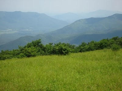


For more information on this hike, please click here.
Jeff
HikingintheSmokys.com Detailed information on trails in the Smoky Mountains; includes trail descriptions, key features, pictures, video, maps, elevation profiles, news, hiking gear store, and more.
In fact, azalea lovers from all over the world come here to visit perhaps the finest display of flame azaleas anywhere on the planet. According to the Great Smoky Mountains Natural History Association the various hybrids of azaleas on Gregory Bald are so impressive and unique that the British Museum of Natural History has collected samples of them.
This isn't an easy hike - the trail climbs over 3000 feet, and the roundtrip hike is 11.3 miles - but it's well worth it. As mentioned in a previous post, I would definitely rate this as one of the top 3 hikes in the Smokies.
Here's a preview of some of the sights you'll see at the top:
For more information on this hike, please click here.
Jeff
HikingintheSmokys.com Detailed information on trails in the Smoky Mountains; includes trail descriptions, key features, pictures, video, maps, elevation profiles, news, hiking gear store, and more.
Frazil Ice
The last gasps of winter in the Yosemite Valley.
Check out this amazing video showing the "giant slurpee" that forms when "frazil ice" collects on Yosemite Falls and flows down Yosemite Creek each spring like a lava flow.
As you might expect, the scenery in this film is awesome:
Jeff
HikingintheSmokys.com Detailed information on trails in the Smoky Mountains; includes trail descriptions, key features, pictures, video, maps, elevation profiles, news, and more.
Check out this amazing video showing the "giant slurpee" that forms when "frazil ice" collects on Yosemite Falls and flows down Yosemite Creek each spring like a lava flow.
As you might expect, the scenery in this film is awesome:
Jeff
HikingintheSmokys.com Detailed information on trails in the Smoky Mountains; includes trail descriptions, key features, pictures, video, maps, elevation profiles, news, and more.
Wednesday, June 2, 2010
Hike of the Month: Spence Field / Rocky Top
It's June, which means mountain laurel is getting ready to bloom at the top of Spence Field.
The hike to Spence Field out of Cades Cove is probably one of the most underrated hikes in the Smokies. I would go so far as to say that the combination of Spence Field and Rocky Top would rate as one of the top three hikes in the Great Smoky Mountains. Gregory Bald would definitely be included in that group, with Mt. LeConte via Alum Cave, Mt. Cammerer or Charlies Bunion rounding out the top three.
In addition to the outstanding views from Rocky Top anytime of the year, the mountain laurel at Spence Field makes this a special hike. The best time to tackle the 5.1-mile trek to Spence is usually right around mid-June when the grassy bald area is exploding with mountain laurel in peak bloom.
Spence Field provides for some outstanding views of the North Carolina Smokies, but if you still have the energy, hike another 1.2 miles to Rocky Top for an even better vantage point - possibly the best in the park.
Here's a preview of some of the sights you'll see at the top:


For more information on Spence Field, please click here, and for more information on Rocky Top, please click here.
Jeff
HikingintheSmokys.com Detailed information on trails in the Smoky Mountains; includes trail descriptions, key features, pictures, video, maps, elevation profiles, news, hiking gear store, and more.
The hike to Spence Field out of Cades Cove is probably one of the most underrated hikes in the Smokies. I would go so far as to say that the combination of Spence Field and Rocky Top would rate as one of the top three hikes in the Great Smoky Mountains. Gregory Bald would definitely be included in that group, with Mt. LeConte via Alum Cave, Mt. Cammerer or Charlies Bunion rounding out the top three.
In addition to the outstanding views from Rocky Top anytime of the year, the mountain laurel at Spence Field makes this a special hike. The best time to tackle the 5.1-mile trek to Spence is usually right around mid-June when the grassy bald area is exploding with mountain laurel in peak bloom.
Spence Field provides for some outstanding views of the North Carolina Smokies, but if you still have the energy, hike another 1.2 miles to Rocky Top for an even better vantage point - possibly the best in the park.
Here's a preview of some of the sights you'll see at the top:


For more information on Spence Field, please click here, and for more information on Rocky Top, please click here.
Jeff
HikingintheSmokys.com Detailed information on trails in the Smoky Mountains; includes trail descriptions, key features, pictures, video, maps, elevation profiles, news, hiking gear store, and more.
Tuesday, June 1, 2010
Brand New Trails Illustrated Maps for the Smokies
 National Geographic now has two separate Trails Illustrated Maps for the Great Smoky Mountains - in addition to the old map. National Geographic has divided the Park in two, thus allowing each map to show much greater detail. The original map, which covered the entire Park, had a scale 1:70,000. The two new maps now have a scale of 1:40,000 (1” = .6 miles) and provide much greater detail such as backcountry campsites, footbridges, fords and stream crossings, nature/interpretive trails, as well as detailed trail mileages.
 The map for the western section of the Park includes the Cades Cove and Elkmont areas. The map for the eastern section includes Clingmans Dome, Mt. LeConte and the Cataloochee areas.
Coverage Highlights Areas and places featured in this map series include: the Appalachian Trail, Benton Mackaye Trail, and the Mountains-to-Sea Trail. The maps also include scenic overlooks and roadside pull-outs.
Of course you can still purchase the original map that includes the entire Park.
Thanks to the blog reader that was kind enough to drop me an email informing me of these new items.
Jeff
HikingintheSmokys.com Detailed information on trails in the Smoky Mountains; includes trail descriptions, key features, pictures, video, maps, elevation profiles, news, and more.
New Bear Warnings in Smokies
The Great Smoky Mountains updated their list of trails, backcountry campsites and shelters that have posted bear warnings, and have added several new locations to the list this morning.
Here's the current list:
• Abrams Falls Trail
• Clingmans Dome Trail and parking lot
• Laurel Falls Trail
• Ramsey Cascades Trail
• Mount Le Conte Lodge
• Mount Le Conte Shelter
• Russell Field Shelter
• Tricorner Knob Shelter
• Backcountry Campsites 10, 12, 13, 29
Additionally, these Backcountry Campsites and Shelters are closed:
• Backcountry Campsites 36, 37
• Mount Collins Shelter
Please note that posted "Bear Warnings" simply means that these are areas where bears are active. Please read What Do I Do If I See A Bear? for important safety information about bears.
Jeff
HikingintheSmokys.com Detailed information on trails in the Smoky Mountains; includes trail descriptions, key features, pictures, video, maps, elevation profiles, news, and more.
Here's the current list:
• Abrams Falls Trail
• Clingmans Dome Trail and parking lot
• Laurel Falls Trail
• Ramsey Cascades Trail
• Mount Le Conte Lodge
• Mount Le Conte Shelter
• Russell Field Shelter
• Tricorner Knob Shelter
• Backcountry Campsites 10, 12, 13, 29
Additionally, these Backcountry Campsites and Shelters are closed:
• Backcountry Campsites 36, 37
• Mount Collins Shelter
Please note that posted "Bear Warnings" simply means that these are areas where bears are active. Please read What Do I Do If I See A Bear? for important safety information about bears.
Jeff
HikingintheSmokys.com Detailed information on trails in the Smoky Mountains; includes trail descriptions, key features, pictures, video, maps, elevation profiles, news, and more.
Subscribe to:
Posts (Atom)